Past several months, provinces in Thailand are hit by severe floods, affecting numerous people, company, industry, and agricultural parts. To remedy the situation, the government and relevant agencies e.g. Royal Irrigation department, Department of Highways, Department of Rural Roads, Bangkok Metropolitan Administration, etc. takes most of their efforts 24 hrs a day, 7 days a week to provide the flood mitigation plan and strategy, to allocate resources, labors, equipments, food and medicines to those who are in need. The distribution of the resource performs together with the flood protection and transportation(people and flood) plan to ensure the most effective and safest way to the country and their Thai people.
Based on the above word "flood mitigation",I today like to introduce its definition and some examples of how the flood mitigation has been generally implemented so that we could see the plan in the big picture.
In general, Flood mitigation involves managing the effects of flooding, such as redirecting flood run-off, rather than trying to prevent it altogether. It is management of people, through measures such as evacuation and dry/wet proofing properties for example. The prevention of flooding can be studied on a number of levels, individual properties, small communities and whole towns or cities. The costs of protection rise as more people and property are protected.
Protection of Individual Properties There are systems that property owners purchase and fit to their home to stop water entering their house. These systems work on blocking doors, windows and air vents with boards.
Protection of Communities
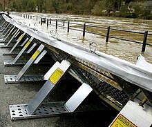
When more homes, shops and infrastructure are threatened by the effects of flooding, then the benefits of greater protection is worth the additional cost. Temporary Flood Defenses can be constructed relatively quickly in certain locations and provide protection from rising flood waters.Rivers running through large urban developments will often have been controlled and channeled. These channels or canals will have a fixed capacity and if flood water flows exceed this capacity then the city will flood. Over time defenses will have been constructed to minimize the effects, and this will generally be through raising the sides of the river channel with embankments, walls or levees. The large number of people and huge value of infrastructure at risk in cities, means that protection works of high cost can be justified.
Flood Risk Management
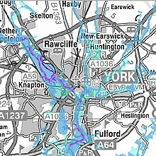
The most effective way of reducing the risk to people and property is through the production of flood risk maps. Most countries in the developed world will have produced maps which show areas prone to flooding events of known return periods. In the UK, the Environment Agency has produced maps which show areas at risk, the map below shows a flood map for the City of York. The dark blue area is the flood plain for a 1 in 100 year flood, whilst the light blue area shows the predicted flood plain for a 1 in 1000 year flood. Engineers will use this map to identify low lying areas which need flood defences, and these are shown purple.
By identified areas of known flood risk, the most sustainable way of reducing risk is to prevent further development in those known flood risk areas. It is important for at-risk communities to develop a comprehensive Floodplain Management plan.[1] Those communities that participate in the National Flood Insurance Program must agree to regulate development in the most flood prone areas. Communities should assign a floodplain administrator to oversee the management of the floodplain development permit process.
The example of the map produced by using GIS and Satelitte Imaging that is benefit in providing the flood area in Thailand is given below:
Credit:1) http://en.wikipedia.org/wiki/Flood_mitigation
2) http://map.longdo.com


Civil engineering is the professional field of designing, building, and maintaining the physical and natural environments. Check out about Civil Engineering Colleges in Nagpur here
ReplyDeleteRBU is one of the most prominent Computer Science Engineering Colleges in Nagpur with programs spanning AI, Machine Learning, Data Science, and Cyber Security. The university provides modern infrastructure, hands-on training, and real-world industry projects, ensuring students excel in IT careers. Visit this detailed program page here: Computer Science Engineering Colleges in Nagpur.
ReplyDelete